We are SmartCity ready. Are you?
We help to build smart city solutions for smart city administrators using smart geoinformation technologies.
The SmartCity concept brings a lot of new possibilities for cities and people. Any big city or a small town can become Smart with our technologies in just a few days. Our Smart solutions help to create safe and happy places for people, better environments for businesses and smart city infrastructure for sustainable growth.
Is your city or town going to become Smart?
Our innovative solutions help to achieve this goal every day.
Key attributes of our SmartCity concept
I want to be Smart!
Selected Smart Solutions
Assetino Cemetery
Assetino Cemetery contains detailed information about graves, deceased, contracts and payments for gravesites. Options to add a photo to every grave place and modules for public enable search by name of deceased, free grave places, etc.
Assetino Waste
Solution for effective waste management contributes to cost reduction with on-line visualization of filling level status, alarm alerting, routing, maintenance optimization, informing citizens etc.
Assetino Water
Assetino Water is a management solution for water and wastewater networks with complex administration tools for water and sewer lines managed by a city, municipality, or an authorized organization.
Assetino Lighting
Application for asset management and maintenance of public lighting - switchboards, masts, cables, cable cabinets, technical elements, lamps, traffic lights. Integration with IoT sensors allows to visualize and to analyze consumption, temperature and other values, efficient maintenance and remote controlling.
Assetino Street Furniture
Street and Park Furniture Asset Management Application. QR codes placed on a street and park furniture enables to improve efficiency of asset management and regular maintenance. Citizens can report any asset demage or issue using the Like/Report app.
Facility Management
GeoFaM is an open, easy to configure platform which provides support throughout the entire life cycle of buildings and structures and their technologies.
Assetino Travel
Excellent web application for citizens that increases traveling comfort by public transport. It provides quick and detailed information about current traffic situation, such as real-time location of buses, trams and trains, their delays, departures from selected stop.
Assetino Report
Crowdsourcing application allowing citizens quickly and easily report non-emergency issues regarding public places and asset, which reduces time needed to fix the issue and keep the community happy. User interface is optimized for all devices (smartphone, tablet, laptop, PC).
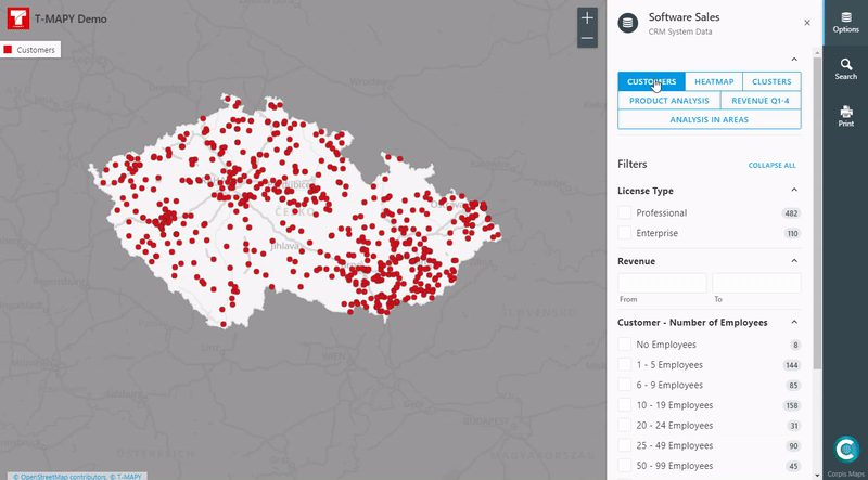
Analytical Maps
Analytical application that enables city data to be spatially analyzed in order to uncover hidden relationships and trends. Data can be filtered, displayed in various visualizations like clusters, heat maps or aggregations in administrative or custom areas.
Most SmartCity Solutions are based on Assetino platform.
Learn more about Assetino platform and Assetino applications.
Smart Analysis
Smart analyses are created in Corpis Maps, easily configurable analytical map platform for advanced spatial analysis.
Learn more about Corpis Maps platform.
Our Smart solutions are all about...
Smart Cities
for Smart people
Hero image credit: Designed by Freepik & jihy | T-MAPY