3D_objekty_aktualita_mini

Official Introduction
of Unique 3D Objects Technology

T-MAPY Introduces
New 3D Objects Technology for Web GIS

3D_objekty_aktualita_nahled

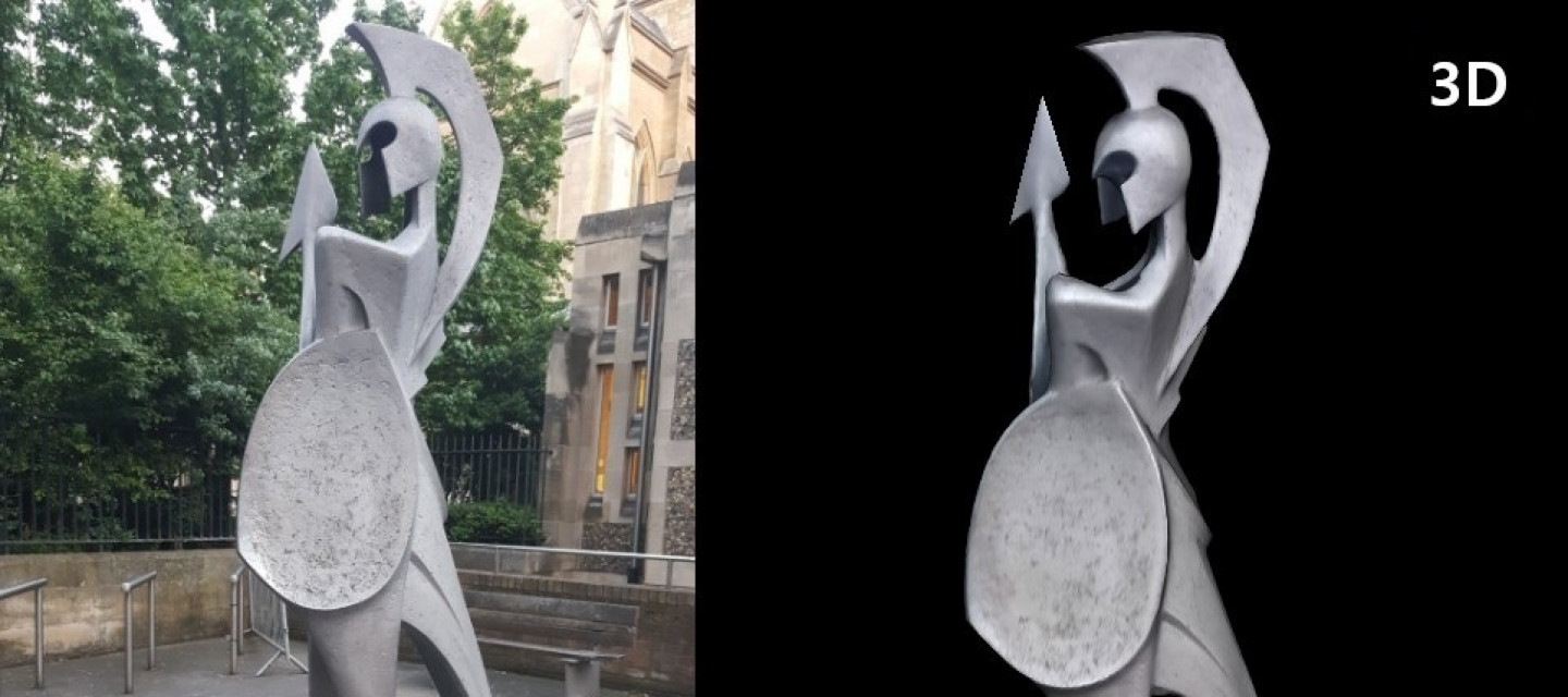
T-MAPY introduced today “3D Objects” technology for T-MAPY Web GIS applications that enables to create, view and analyze 360° 3D models of real objects.

360° 3D models represent a brand new attribute type of GIS features. It allows interactive viewing and analyzing of the whole objects or its parts. 3D models have very high information and documentation value and the best thing is that they are directly integrated in T-MAPY Web GIS apps using the 3D module. 360° 3D models of the real objects are available either for internal purposes or public or both depending on a client’s need."We are the world’s first and the only one Web GIS that enables users to use 360° 3D models directly in Web GIS." said Jaroslav Polacek, product manager of 3D Objects technology. “360° 3D models can be used for many different purposes including the documentation of sculptures or memorials, the same 360° 3D models can be used in a public map for tourists and help a town, city, region, country to increase income from tourism.”

T-MAPY Web GIS is a leading Web GIS with most of users in Europe.

Availability

T-MAPY 3D Objects technology and 3D Module for T-MAPY Web GIS are available from today. For more information, please visit the product website or contact our Reseller Partners.

Do you like the 3D Objects technology and our Web GIS?

About T-MAPY

Founded in 1992, T-MAPY has grown to become a key provider of geospatial solutions. Our extensive know-how and experience in geoinformatics, information technology, geography, cartography, data processing and analysis and much much more allows us to design and develop standalone geospatial solutions for public administration, emergency services, transportation, and the private sector.

3D Module in Web GIS
3D Model Preview in the Info Panel
City transport

Another Successful Deployment of the New T-MAPY Dispatching Control System

T-MAPY successfully completed another large transport project. A few days ago, the IDSOK Dispatching Control System was officially handed over to the client - Coordinator of the Olomouc Regional Integrated public transportation system (KIDSOK).

reference-logo-kidsok

The project was running 7 months and the goal was to create a complex Dispatching Control System for integrated transport system (regional bus transport, public city transport and train transport) in the Olomouc Region.

dispecink3

Application for dispatchers

What is the Dispatching Control System good for? It is a tools for a dispatcher for tracking, monitoring and coordination of connections of individual modes of transport, securing of guaranteed connections, dealing with emergency situations, communication with other dispatchers and other tasks. The analytical part of the dispatching system includes a statistical and analytical module that increase effectivity and efficiency of dispatchers, which helps to optimize timetables, transport network and lines and enables complex analysis.

dispecink1_mini

Why is the T-MAPY Dispatching Control System so unique? It includes an algorithm for prediction of the future, which helps a dispatcher to prevent many problems in the individual connections delay modeling, comes with a modular concept and a fully configurable user environment that is oriented to the maximum comfort and efficiency of the work of the dispatchers. The Dispatching Control System also communicates with other systems, from which it receives data (eg. The Integrated Traffic Information System for the Czech Republic) or provides data or communicates with them (stop panels, telephone exchange, ...) in other way.

dispecink_nehoda_mini

Application for public

A part of the system is a popular public application, that allows users to track a real-time position of a selected connection, its delay and get an information about the carrier, the detailed timetable of the selected connection, etc. It is also possible to search departures from selected stop or search for a particular connection.

All the data in the system is displayed in real-time (or in a selected time interval). The IDSOK system stores the records every 6 seconds (it is millions of records every day), so that it provides accurate information about the current link location.

dispecink_aplikace_pro_verejnost_mini

If you are interested in more details about the unique T-MAPY Dispatching Control System, please contact us.

london_japo_geo_hero

T-MAPY at the GeoBusiness 2017 Conference in London

The GeoBusiness 2017 Conference was held in London on May 23-24 and more than 160 exhibitors and 3000 visitors from around the world attended including Jaroslav Polacek from our company. It was a great opportunity to see the latest geospatial technologies in action and meet with manufacturers and users. One of the main topics of the conference was SmartCity, which is getting more importance also in the Czech Republic.

london_japo_geo_small

We received very positive feedback to our Web GIS thanks to the unique feature released just a few weeks ago called „3D objects“, modern user interface, speed and stability of the solution and excellent cartographic outputs.


SmartCity presentations were mostly about the need of smart transportation, sharing data and information between citizens and councils, analysis and visualization of data from smart sensors in a map. We at T-MAPY have specialized Smart City solutions (not only) for these areas.


At the conference, there was an opportunity to try the Mixed Reality technology Hololens, we enjoyed exploring the 3D model of a city. :-)

japo_geo_business_2017_small

Copyright © 2024 | T-MAPY spol. s r.o.